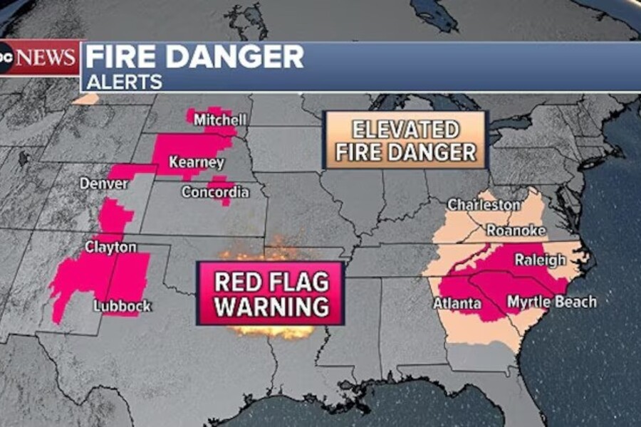
More than 25 million Americans remained under red flag warnings Saturday as much of the nation grappled with dangerous wildfire conditions fueled by warm temperatures, dry air, and gusty winds. The alerts, issued by the National Weather Service, stretched across large portions of the Central U.S. and Southeast, placing several major cities — including Denver, Raleigh, and Atlanta — at risk.
The warnings, which signal elevated fire danger, come amid ongoing firefighting efforts in areas like Miami-Dade County, Florida, where a wildfire burning in the southeast portion of the county reached 65% containment Saturday. Local officials say firefighters are working around the clock, and although no roads to and from the Florida Keys were closed as of Saturday afternoon, residents were urged to stay alert.
“Firefighters continue working around the clock to contain the fire,” said Miami-Dade County Mayor Daniella Levine Cava. “We continue to advise residents and commuters to stay informed and alert in case conditions change.”
While Florida’s winds are expected to ease Saturday evening, improving containment efforts, other parts of the country are facing worsening conditions. In New Mexico and West Texas, forecasters say a “critical” fire threat exists — the second-highest rating on the fire risk scale — due to sustained winds of 15–25 mph and low relative humidity. Gusts could exceed 40 mph, further increasing the likelihood of fast-moving wildfires.
Red flag warnings were also issued for parts of the Southeast, with the greatest risk affecting the Carolinas and northern Georgia. Although wind speeds in the region aren’t expected to reach extreme levels, the combination of dry vegetation and even moderate gusts could trigger fires. Warnings in these areas remain in effect until at least 8 p.m. ET Saturday.
The most intense danger, however, is centered over the Plains. The weather service issued red flag warnings across a wide corridor from the Texas Panhandle through South Dakota, including metro Denver, where gusts of 40 to 50 mph are expected. Fire weather specialists warn that such conditions can lead to explosive wildfire behavior.
Despite a slight improvement expected on Sunday as winds decrease, many regions will remain abnormally dry, keeping the risk of new fires elevated. Areas in the southern Plains — including parts of Texas, Oklahoma, and Nebraska — will still face fire weather concerns throughout the weekend.
As fire danger escalates in the central U.S., northern states are dealing with a completely different threat: winter weather. A storm system moving across the Midwest is bringing snow and icy conditions to parts of Minnesota and Michigan’s Upper Peninsula. Winter weather alerts were issued for these areas, with snowfall totals of 3 to 7 inches and the possibility of light ice accumulation.
Meanwhile, farther south, the same system is sparking thunderstorms and the threat of severe weather. A marginal risk (level 1 out of 5) for severe storms was issued Saturday evening for areas including eastern Kansas, Missouri, northeastern Oklahoma, and northwestern Arkansas. The primary threats are damaging winds and large hail, but forecasters cautioned that isolated tornadoes could not be ruled out.
Looking ahead to Sunday, the system is expected to intensify as it moves east, with a greater risk of severe weather across the Lower Mississippi River Valley and Deep South. More than 4 million people across Texas, Louisiana, Mississippi, and Tennessee are under a slight risk (level 2 of 5) for strong storms Sunday afternoon and evening. Along with damaging winds and hail, a few tornadoes and localized flash flooding are possible.
Emergency management officials across the country are urging residents to stay informed and take warnings seriously. In areas under red flag warnings, people are advised to avoid outdoor burning, limit use of machinery that could create sparks, and follow local fire restrictions. For those in areas at risk of storms or flooding, preparedness measures such as securing property and having emergency plans in place are recommended.
This weekend’s convergence of extreme fire weather, winter storms, and severe thunderstorms reflects the volatile and often unpredictable nature of springtime weather in the United States. As conditions continue to shift, authorities and weather experts stress the importance of caution, vigilance, and preparedness.
